Amboseli Wildlife Corridors
Amboseli-Kimana ecological overview: Dr. Evans Mwangi, ACF Director
Introduction
The target land parcels lie within the vital wildlife corridor linking three of Kenya’s most celebrated national parks: Amboseli, Chyulu and Tsavo West. They fall along a critical wildlife pathway in the former Kimana-Tikondo group ranch which has since been subdivided and sold out to individual interests. They are also located adjacent to the Kimana Wildlife Sanctuary within the larger Amboseli ecosystem, which ecosystem covers an area of approximately 5,700 Km2 stretching from the Chyulu hills in the northeast to the base of the Kilimanjaro at the Kenya-Tanzania Border to the south. The ecosystem comprises the Amboseli park, surrounding group ranches and numerous private land holdings.
The Kimana Sanctuary partly lies within the Kimana swamp, located at the junction of the Kimana and Isinet Rivers and fed by underground water seepage from Mt. Kilimanjaro as well as surface run-off during the rainy season. It resulted from efforts in the 1970s when the Amboseli national park pioneered in working with surrounding communities to protect critical natural resources across the entire ecosystem. This kicked off a nation-wide movement which encouraged wildlife-based enterprise, and ushered in ecotourism as an avenue for benefiting from wildlife on community lands. Formed in 1994, this was one of the earliest community initiatives in the country that was heralded as a flagship the “people’s park”. Together with adjacent properties the sanctuary currently functions under the auspices of the Amboseli Land Owners Conservation Association (ALOCA).
Beginning in the 1970s, the communally owned lands of then Kajiado district were divided into group ranches under jointly held title deeds (Western and Mose 20211, Kimani and Pickard 19982, Grandin 19913). Internal pressure to secure land against outside interests led to the eventual subdivision in some of these to individual allotments (Ntiati 20024, BurnSilver and Mwangi5 2007). This led to a rise in local Maasai holding individual titles and fuelled a land sales frenzy that resulted into immigrant farmers rushing for the arable slopes of the Kilimanjaro and plots adjoining the swamps east of Amboseli (BurnSilver et al. 20086).
As a microcosm of the wider ecosystem, the immediate locality fits the general description, with the continued deterioration being reflected as widely reported in the literature. The main causes are attributed to a rapid increase in human population and settlement, overstocking, and spread of cultivation. The permanent wetlands have suffered severe decline and degradation as a result, while vital migratory corridors are being fenced off relentlessly. The growth of urban settlement, unplanned tourist infrastructure and irrigation pose an increasingly serious existential threat to wildlife.
An increasingly sedentary and predominantly farming cum business-oriented community has attracted the proliferation of key services such as markets, schools, medical facilities, water provision and religious institutions. The upgrading of physical infrastructure – such the Emali-Loitokitok road bisects the core area to the detriment of east-west wildlife migration – marks another critical milestone and a major ecological disruption.
Topography
The area has a relatively flat topography with scattered small depressions and broken in only a few places by a number of small hills, in the backdrop of . steadily rising ground toward the Kilimanjaro. Most precipitation is derived from convection emanating from the Indian Ocean Dipole. Surface runoff percolates into the basaltic bedrocks and the groundwater flow feeds the swamps, sustained by springs and one ephemeral river entering from the east.
The general area is located at an elevation of approximately 1199 m above sea level. It experiences temperatures averaging 21˚-25˚C, though this could reach a high of 35˚C in the dry season. Annual rainfall averages 350 mm per annum, falling mainly between March – May and October – December. Broadly, the undulating plains are characterized by soils that vary depending on parent material and the landforms (Gachimbi, 20027). These range from deep, friable and firm sandy clay soils to moderately deep Ferral-chromic Luvisols clay on upper elevations.
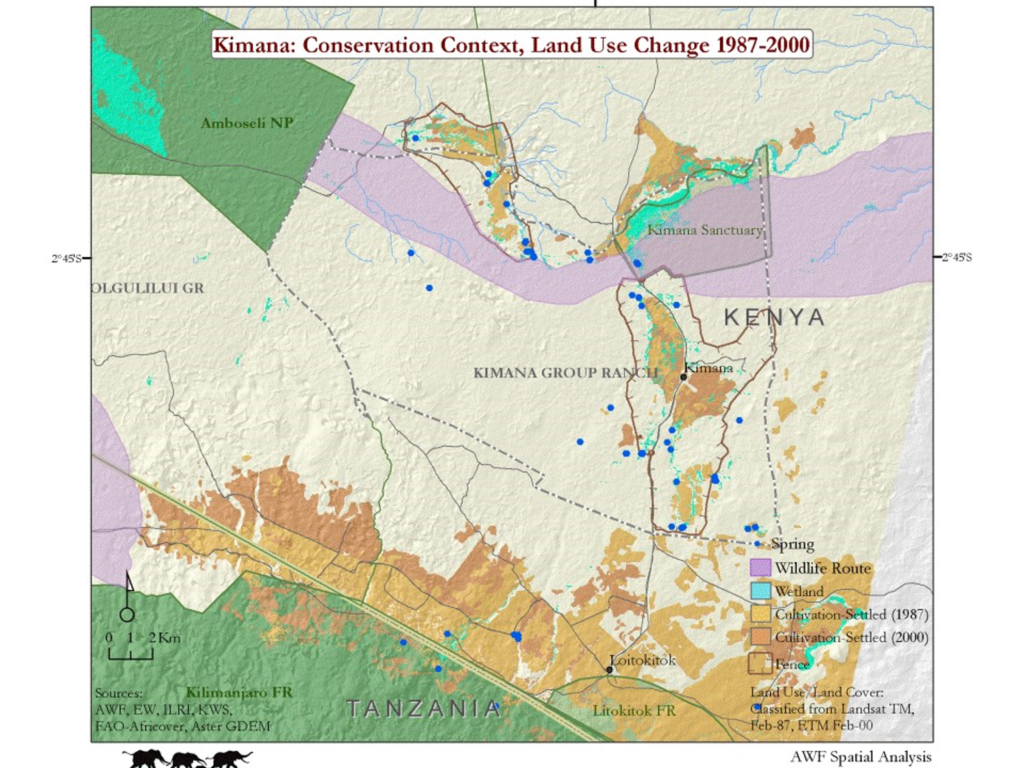
The figure below illustrates the general landscape features and landuse trends culminating in the group ranch subdivision into individually held parcels.
The biodiversity
Set in the spectacular of Kilimanjaro to the south and the Chyulu Hills to the northeast, the biodiversity is equally fascinating. The open plains are dotted with Thompson’s (Eudorcas thomsonii) and Grant’s gazelles, (Gazella granti), plains zebras (Equus quagga, formerly Equus burchelli), and Maasai Giraffe (Giraffa camelopardalis). Groups of African elephant (Loxodonta africana), African buffalo (Syncerus caffer), white bearded wildebeest (Connochaetes taurinus), impala (Aepyceros melampus), Cokes hartebeest (Alcelaphus buselaphus cokii), common eland (Tragelaphus scriptus), common warthog (Phacochoerus aethiopicus) and yellow baboon (Papio cynocephalus) are equally visible, as are waterbuck (Kobus ellipsiprymnus) and Hippopotamus (Hippopotamus amphibious) nearer the swamps and along rivers banks. Smaller ungulates found in the area include the common duiker (Sylvicapra grimmia) and Kirk’s dik-dik (Madoqua kirkii). Big carnivores include the lion (Panthera leo), leopard (Panthera pardus), spotted hyena (Crocuta crocuta), and the occasional cheetah (Acinonyx jubatus). There are also numerous small mammals, reptiles, and amphibians.
The river valleys are lined by magnificent yellow-backed acacia (Acacia xanthophlea Benth) from where vervet monkeys (Chlorocebus pygerythrus) watch from the branches, while the umbrella acacia (Acacia tortillis Forssk.) silhouete the skyline. The swamps are dominated by Cyprus immensus and Salvadora persica. Many wetland birds use the swamps, including several species of global conservation concern. The presence of surface water also determines role as a dry season refuge. Further out are the characteristic Acacia–Commiphora bushland and woodlands, interspersed with open grassland dominated by Pennisetum spp, with a rich avian fauna containing a significant part of the more than 400 species recorded in the ecosystem.
Importance for the conservation habitat, wildlife populations and community livelihoods
Whereas the group ranch system was predicated on a collective livestock and natural resource production enterprise concept, the necessity of joint management proved a major stumbling block. However, future viability still depends on building shared responsibility and decision-making among stakeholders, joint and collaborative management plans. It remains a key imperative for any success of conservation, as the wildlife requires widespread dispersal and resource is still subject to joint tenure.
As an ecosystem-wide imperative, maintaining connectivity is essential for sustaining the distribution, genetic diversity, and health of animal and plant populations. The conservation of the habitat and populations cannot be achieved without deliberate efforts to restore intact rangelands for both wildlife and livestock. It also heralds a turning point for exploring the possibility of reconsolidating portions of the sub-divided ranch in order to enhance community livelihood opportunities. A well established fact is that functional wildlife conservancies represent the only remaining hope for securing critical ecological interactions for previously large species aggregations in Amboseli. The sanctuary entirely relies on the corridor to link it to the other protected areas so as to boost its wildlife diversity and enhance tourist experience.
The above is well demonstrated by the two of the key migratory grazing species in the ecosystem, zebra and wildebeest, which show large differences in wet and dry season distribution. They share the same dry season concentration area that includes Kimana swamp and others to the east of the park (Namelok, , Lenker and Soit Pus8). Elephants extensively use the corridor. Almost 18 elephant track movements per day were recorded in a single study between September 2016 and August 2017. In another study undertaken during the dry season in 2012, Kimana had a wildlife density of 47.02 individuals per km2 comprising 15 species9. The most common habitat type was bush grassland (37%), with eight others each occupying below 20% of the sanctuary.
It is easy to envision how population and habitat gaps can negatively affect conservation success. Wildlife corridors are important to allow animals to move from one habitat patch to another which enables them to search of food and mates, for example. This reduces chances of ecological isolation and attendant implications such as the increases risk of species extinction, genetic drift, inbreeding and loss of buffer against extreme droughts and climatic change.
References
1 Western, D., and V. N. Mose (2021). The changing role of natural and human agencies shaping the ecology of an African savanna ecosystem. Ecosphere 12(6):e03536. 10.1002/ecs2.3536
2 Kimani, K., and J. Pickard (1998). Recent trends and implications of group ranch sub-division and fragmentation in Kajiado District, Kenya. Geographical Journal 164:202–213.
3 Grandin, B. E. (1991). The Maasai: socio-historical context and group ranches. Pages 21–39 in S. Bekure, P. N. de Leeuw, B. E. Grandin, and P. J. H. Neate, editors. Maasai herding: an analysis of the livestock production system of Maasai pastoralists in eastern Kajiado District, Kenya. International Livestock Centre for Africa, Addis Ababa, Ethiopia
4 Ntiati, P. (2002). Group ranches subdivision study in Loitokitok division of Kajiado District, Kenya. LUCID Working Paper, Number 7. International Livestock and Research Institute, Nairobi, Kenya
5 BurnSilver, S., and E. Mwangi. (2007). Beyond group ranch subdivision: collective action for livestock mobility, ecological viability, and livelihoods. International Food Policy Research Institute, Washington, D.C., USA.
6 BurnSilver, S. B., J. Worden, and R. B. Boone (2008). Processes of fragmentation in the Amboseli ecosystem, southern Kajiado District, Kenya. Pages 225–253 in K. A. Galvin, R. S. Reid, R. H. Behnke Jr., and N. T. Hobbs, editors. Fragmentation in semi-arid and arid landscapes. Springer, Berlin, Germany.
7 Gachimbi, L. (2002). Technical report of soil survey and sampling: AmboseliLoitokitok Transect. Lucid Technical Report.
8 David Western (2007) The ecology and changes of the Amboseli ecosystem. Recommendations for planning and conservation. A report submitted to: The Task Force for Developing the Amboseli Ecosystem Plan Amboseli Conservation Program at African Conservation Centre Nairobi. September 14th 2005 Revised 5th April 2007
9 Poelking, Claire (?) Assessment of habitat and wildlife density in Community Wildlife Sanctuaries Amboseli Ecosystem, Kenya. Senior Honors Thesis. Department Geography University of Wisconsin – Madison